Have You Ever Seen the Old Man of the Mountain? – Franconia Notch State Park, NH, May 2017

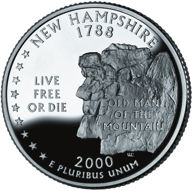
This spring our plan was to complete our goal to camp in all 50 states. That is what brought us to New Hampshire and Franconia Notch State Park. Franconia Notch is a scenic mountain pass, traversed by a parkway winding between the high peaks of the Kinsman and Franconia mountain ranges. As a teenager I camped in Franconia Notch State Park with my family. At that time we were able to see a geological feature known as the Old Man of the Mountain. This granite formation has been here for centuries, and is featured on the New Hampshire quarter. Over the decades, there was increasing erosion and decay of the formation and in the summer of 1958 the state emplaced four steel rods with huge turnbuckles, weighing up to 700 pounds, to hold the forehead in place. They sealed cracks with fiberglass to keep water from seeping into the granite and prevent further erosion. Unfortunately on May 3, 2003, it all failed. Apparently the granite that supported the chin had been weakened by decades of water reacting with the feldspar potash and the chin fell from the mountain. Once the chin fell away, the remainder of the face was unsupported and it collapsed within seconds – The Old Man of the Mountain was gone.

Since my trip as a teenager, the park opened up an RV park near Cannon Mountain. The sites are at the end of the parking lot for the Echo Lake beach. This may not sound pleasant, but it made them real easy to back into. There are pine trees between every site, and the sites back up to a grassy slope with Cannon Mountain in the background, a great view. I don’t know what it is like in the summer, but this early in the year, there was hardly anyone in the lot.

As soon as we were set up we drove to the Visitor Center to get general information on the park and information on hiking in the area. We only had part of the afternoon left and we decided to take a short hike at a site called the Basin. Here a mountain brook had eroded the rock face and formed a rock bowl, or basin. It is amazing to see what water can do to solid rock, over the centuries it continually and relentlessly wore away at the rock, the power is irresistible.

The weather was clear the next morning and we hiked up to the Artist’s Bluff where we had a spectacular view of the Franconia Notch, Echo Lake, and our campground. From there we continued to the higher peak of Bald Mountain. The trail was well marked, but not for the faint-hearted. At times it was more like rock climbing than hiking, but that only added a bit of spice to the experience.

After we cleaned up we decided to give ourselves a special treat and drove to Patty’s Pancake Parlor for lunch. Obviously their specialty is pancakes. They offer different flour and add-ins, such as chocolate chips and blueberries. Because each guest can order multiple combinations, the servers prepare the pancakes themselves. In short, the food was good, the prices reasonable, and the service was great. I recommend Patty’s Pancake Parlor to anyone visiting Franconia Notch.

It looked like that day was going to have the best weather so we decided to hike the Flume gorge that afternoon. Other than the Old Man of the Mountain, the most significant geologic feature is the Flume. The Flume is a natural gorge with spectacular waterfalls, vistas, and covered bridges. The trail is paved for the first part, but then you go uphill along a walkway/stairs that allows you to look down into the flume. The way the water has cut into the mountain in such a sharp gorge is impressive. At spots you can see where dark volcanic lava has filled in the cracks formed in the lighter shade of granite. The covered bridges added something special to the hike.

The next morning we awoke to somewhat clear skies. Partly cloudy is turning into the new clear. Is this rain ever going to stop? We took advantage of the good weather, packed a lunch and drove to the trailhead for the Falling Waters Trail. This trail goes to the top of the ridge where it  meets the Appalachian Trail at a spot called the Haystack. We set out, planning to make it to the Haystack. The trail started our easy enough, but soon we were climbing. On our way to the top, we had to traverse four “wet” crossings. This is where the Walker Brook and Dry Brook crossed the trail and there was no bridge on the trail. These crossings definitely added some excitement to the hike, and we had a few challenges on a couple of them.

As we climbed the scenery of the brooks tumbling down the mountain was magnificent. As opposed to the Flume where we were restricted to walkways and trails, here we could go wherever we wanted. We thought some of the parts of the trail to Artist’s Bluff were tough, but climbing over the rocks and boulders on the Fallen Waters Trail made those look mild. After the fourth water crossing we took a break and chatted with other hikers as they passed us. Finally we decided that it was time to turn around. I checked my GPS and determined that we had climbed 1130 feet since we left the trailhead, no wonder we were feeling it! You would think it would be easier going back down, but that was not the case. As we descended we had to traverse the climbs we had made over those rocks and boulders. We had to be careful as more climbers get hurt going down than going up.

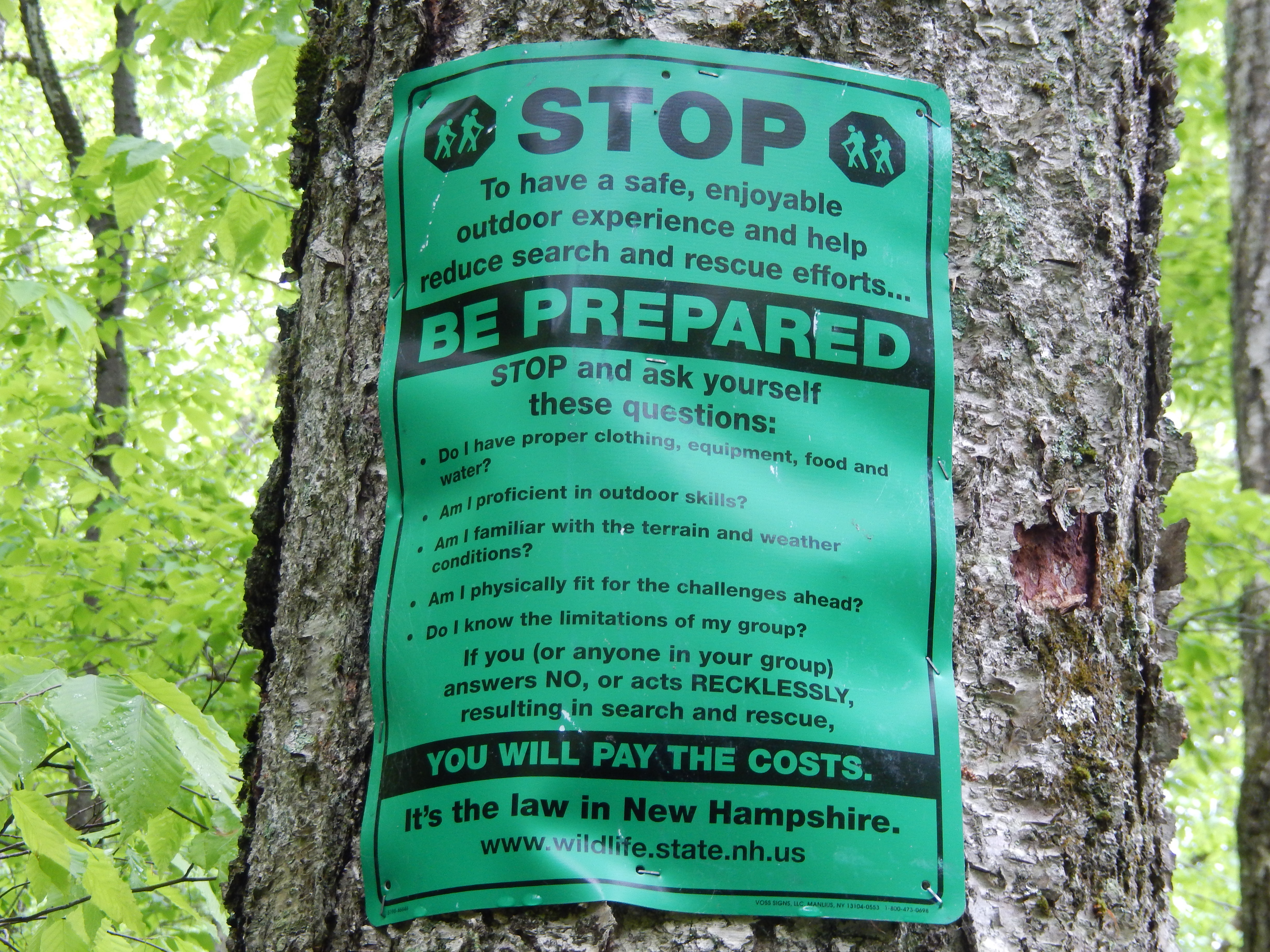
Earlier, at the visitor center, we had seen information on a program where you could purchase a card for $25 that would cover the cost of your rescue if you got into trouble. As we started out on the Fallen Waters Trail we saw a sign that clearly stated if you are not properly prepared or act recklessly and had to be rescued, you would pay the cost of that rescue. I joked about paying $25 in case you are stupid, but as we discussed it we changed our minds. If you’re a local and are on the trails a lot it would be fairly easy to make a mistake and get hurt to the extent that you had to be rescued, and $25 wasn’t a bad insurance policy.

We made a couple more stops on our way back to the trailer and one was Boise Rock. In the 1800s a teamster named Thomas Boise was caught in a blizzard and took shelter under this rock. To survive he had to kill and skin his horse, and wrap himself in the hide. When his rescuers found him the next day, the horse’s hide was frozen around his body and they had to cut it off of him with axes, but he survived the blizzard because of it.

Our final stop was at the Old Man of the Mountain Profile Plaza. Here we were able to see in detail how people had attempted to preserve the Old Man’s face on the mountain and how nature took her course in spite of their efforts. One of the best features of the Plaza are the metal stands they have built to replicate the profile that used to be the Old Man of the Mountain. When you stand on the designated footprints for your height, you can look at this metal arm and see this replica of what used to be the profile of the Old Man of the Mountain. How special to allow people who have heard of this to still be able to see what is no longer there!

Next to the Old Man of the Mountain Profiler Plaza is the New England Ski Museum. Downhill skiing got its start in the United States in this area. In fact, the first Ski School in the USA is in a small village nearby. This museum is dedicated to that history of skiing. The museum is small, well done, and free to all. When we visited it, they had a special exhibit on the 10th Mountain Division that was formed in World War II at the urging of skiers and mountaineers from this area.

The next morning we had the “enjoyment” of packing and hooking up in the rain. Next stop, Burlington, VT.

Posted in Fulltime RV, Michigan Traveler, National Parks, New Hampshire | Tagged , , , , , , | 6 Comments

Pleasant Memories of Boston, May 2017

In my last post I described the Revolutionary War history that can be seen in almost every nook and cranny of the Boston area, but there is more to see than the Freedom Trail and the Battle Road.

We stayed at the FAMCAMP (Air Force Campground) at Hanscom Air Force Base near Bedford, MA. This is a nice campground, just across the airfield from the base. There are full hook ups available with 30 and 50 amp electrical service. One of the nice aspects about the campground is the community fire circle with firewood stocked for anyone to use. However the best thing about this campground is that it is a short ride to the Minuteman Bicycle Trail.  This is a Rails to Trails bike/pedestrian path that puts you at a ten minute bike ride to the North Bridge in Concord or a fifteen minute ride to Lexington Green. To go into the City of Boston, it is a short twelve mile drive to the Alewife T-Station to take the train into the city. Talk about convenience!

After touring the historical sites in the area we took our kayaks to the Concord River and paddled under the North Bridge. The Concord River is a nice river for paddling as the current is mild enough that you can paddle up and down stream with little effort. Because there has been so much rain in the area, the river was well above its normal level.  It’s always fun to paddle back in the trees.

We stopped by the North Bridge for lunch and found out there was a small concert scheduled nearby that afternoon.  We finished our paddling and drove back to the bridge. We were entertained by two local musicians that played the violin and banjo, but also played a wide variety of unique instruments that I had never seen before. It was a free concert, sponsored by a local group and a great way to spend an afternoon.

On our last day we observed Memorial Day by attending the ceremony in Bedford. While the parade and outdoor events were cancelled due to the poor weather, the ceremony was held in the high school auditorium. I was most impressed by the speaker from Hanscom AFB, a Lieutenant Colonel, who reflected on meeting a veteran while shopping one day. He said the man seemed to need to tell the stories of his fellow vets that had passed away. In closing his presentation the Lieutenant Colonel said that he had once been told that you are only really dead when people don’t say your name anymore. That is why we observe Memorial Day, to speak the names of those who made, in Abraham Lincoln’s words, “that last great act of devotion.”

That evening we had a potluck dinner with our fellow veterans at the campground and Tuesday, May 30th we left for Franconia Notch State Park in New Hampshire.

Posted in Celebrating Holidays, Fulltime RV, Massachusetts, Michigan Traveler, Military RV Parks | Tagged , , , , , | Leave a comment

The Freedom Trail and the Battle Road, Boston, MA – May 2017

This was our third trip to the Boston area. The last time we were here for three weeks and did a thorough job of exploring the sights.  We had explored Boston, but we had not walked the Freedom Trail. The Freedom Trail is Boston’s 2.5 mile historic walking tour of 16 nationally significant original sites related to the American Revolution. We also saw a number of historical sites not related to the Revolutionary period. The Trail is marked by a red brick path and tells the tales of brave men and women who dared to challenge the mightiest country on earth to win their freedom.

There are guided tours, but we chose to download an audio tour from the Freedom Trail Foundation for only $15 that we could use on both of our MP3 players, and a tour map that I put on my smart phone. We thought this worked best because we could move at our own pace, stay as long as we wanted at any spot, and stop for lunch along the way.

The tour started at the Boston Common where cattle were grazed and British soldiers camped.  In 1634 Puritan settlers established the Commons, making it the oldest public park in the country.

The Massachusetts State House is a formidable structure with a rich history as well as being the seat of state government. Paul Revere laid the cornerstone for it in 1795. There are daily tours on the second floor.

Across the street from the State House is the Shaw Memorial that commemorates the Massachusetts 54th Regiment. Colonel Robert Shaw and his family were staunch abolitionists and he raised a regiment of African-American soldiers. He and the regiment fought with distinction at the battle of Fort Wagner during the Civil War, proving that African-Americans could fight alongside white regiments as equals. The movie, “Glory” with Matthew Broderick and Morgan Freeman does a good job of telling this story.

The Granary Burying Ground is next to the Park Street Church and holds the remains of many Revolutionary heroes such as Paul Revere, John Hancock, Samuel Adams, James Otis, and the victims of the Boston Massacre.

The Old State House was the primary governmental building in colonial Boston.  It was from here that the Declaration of Independence was read to the citizens of Boston. Only a few steps from the Old State House is the site of the Boston Massacre. This was one of the key acts that set in motion the series of events that would lead to the Declaration of Independence and the Revolution.

Faneuil Hall was another major meeting place for the city of Boston. Attendees (at town meetings that were held here) heard Samuel Adams and others lead the cries of protest against the British taxes. The ground floor is currently used by vendors to market their wares much as it was during colonial days.  Quincy Market was built directly behind Faneuil Hall to expand the market and is still used for this purpose. We had lunch in the Quincy Market and, while the place was packed with shoppers, we had no problem finding a place to sit. Don’t let the crowd scare you off.

Boston’s North End is the oldest residential neighborhood and includes Paul Revere’s house, built in 1680. The Revere family occupied the house from 1770 to 1800. The house was used as a cigar factory and a bank before it was purchased and restored by the Paul Revere Memorial Foundation. Revere was quite the businessman and had several successful business endeavors, he even gave dentistry a try.

Probably the most famous church in Boston is the Old North Church, although it is actually Christ Church. It is Boston’s oldest church building and remains an active Episcopal Church. Inside you can see the pews that were owned by the various families. A new exhibit next door is the Captain Jackson’s Historic Chocolate Shop. Here we saw how chocolate was made in colonial times and had a free sample. It was good, but certainly not the milk chocolate we are used to today.

The Battle of Bunker Hill was actually fought on Breed’s Hill. Approximately two months after the British troops fired on the local militia at Lexington Common and Concord Bridge, the Massachusetts Militia built an earthwork redoubt to defend the Charlestown Peninsula. The British troops moved by boat across the Charles River and assaulted the Militia’s left flank. The Militia beat off two British attacks and, only because they ran out of ammunition, they were defeated in the third assault. The British may have won the battle, but the cost was huge, they lost more troops than they could afford and they realized that the Colonists were a force to be reckoned with.

The Charlestown Navy Yard was an active naval yard from 1800 until 1974. It is home to the USS Constitution, known as “Old Ironsides.” The Constitution is the oldest serving warship in the world still afloat and is still on the Navy’s rolls as an active warship. Also on display is the USS Cassin Young, a destroyer representing the type of ship built here during WW II.

Exploring the “Battle Road.”

Before the famous Battle of Bunker Hill, Colonial spies discovered that the British were going to march to Lexington and Concord to capture stocks of hidden arms and ammunition and arrest Samuel Adams and John Hancock. This set in motion the events that led to the “shot heard round the world.”

Paul Revere and William Dawes set out on horseback to warn Adams and Hancock and to alert the Minute Companies of the Militia. The Minute Companies, or Minute Men, were volunteers from within the local militia who were the most motivated and best trained citizen soldiers, and the forerunners of today’s National Guard.

I suggest that you start your tour of the Battle Road at Lexington. It was here that the British were first met by the militia, then go to the North Bridge in Concord where the British were forced to retreat back to Boston after being repulsed by militia at the North Bridge. The retreat to Boston is the Battle Road where the British were continuously attacked by ambushes and sniping by militia for more than ten miles. Let me lead you through the events of that fateful day.

On the night of April 18, 1775 Revere and Dawes were dispatched. At 1:00 AM on April 19th Dawes and Revere met Samuel Prescott, who joined them on their mission. They were stopped by a British patrol and Revere was captured.

At 5:00 AM, 77 members of the Lexington Militia, under the command of Captain Parker, formed on Lexington Commons to face the British. The British fired a volley, eight militia were killed, and the remainder retreated.

As I looked at the Lexington Commons, I could imagine the thoughts going through the minds of these 77 militia men as they faced several hundred well-trained British Redcoats and understood why they fled after the first volley.

By 7:00, the British column had arrived in Concord and began searching the houses for the hidden munitions. At 9:00 the British marched to the North Bridge in Concord where they were confronted by militia from several towns. Militia Major John Buttrick ordered his men to march to the bridge but not to fire unless ordered to do so. British soldiers fired, killing two militia and Buttrick ordered his men to fire.  This order was an act of treason against the Crown and the “shot heard round the world” was the first true shot of the American Revolution.

The British withdrew from Concord, regrouped, and began their march back to Boston.

At 12:30, the British reached Meriam’s Corner and were ambushed by militia Minute Companies. This was the beginning of the running battle back to Boston.

Along the route you can see the stone fences lining the Battle Road. At the time of the battle there were more open fields than we see today. There are restored buildings along the route, such as the Wittemore House, the Hartwell Tavern, and the home of Captain William Smith who commanded one of the militia companies in the battle. As you look down the route, picture the British column, marching four abreast, getting ambushed from a nearby woodlot or stone fence line. British soldiers described it as “an incessant fire like a circle that followed us as we marched.”

Throughout the day 4,000 reinforcements from neighboring militia joined the fight along the Battle Road. They continued to snipe and ambush the British column.  British flankers from their “light” companies tried to force the militia away from the column. The militia fought from abandoned homes along the route and from behind stone fences along the fields, leapfrogging to keep ahead of the British column. At 2:00, Captain Parker and his Lexington militia got their revenge by attacking the British column near the site of Paul Revere’s capture.

At 3:00 the British column was at the end of their resolve and feeling defeated, they staggered into Lexington and were joined by reinforcements from Boston who fired their cannons into the colonial militia.

Although reinforced, the British column continued to retreat toward Boston. At 4:30 newly arrived militia units fought from within homes in the town of Menotomy and inflicted the greatest number of casualties of the day.

By 7:00 the British finally reached the safety of Boston. The militia encircled the British garrison in a siege that would last for eleven months.  Two months later the British attacked the colonial fortifications in the Battle of Bunker Hill.

Writers of the history of the Revolutionary War often discuss the militia as an undisciplined and unreliable force, compared to the better trained and equipped Continental Army. However, in April and June of 1775, along the Battle Road and at Bunker Hill they fought, and fought hard, with bravery and skill, in these opening days of our war for freedom.

Posted in Fulltime RV, Massachusetts, Michigan Traveler, National Parks | Tagged , , , , , , , , , | 4 Comments

The Mystic Seaport of Connecticut and the Mansions of Newport, RI, May 2017

Our next goal was to camp in Connecticut and Rhode Island  to check them off our list of states in which we hadn’t camped yet. We chose to stay at the Seaport RV Park in Connecticut without really knowing what there was to do in the area. 

The RV park is named after the biggest attraction in the area – Mystic Seaport. This is like the Greenfield Village of New England! They have recreated the historic seaport town of Mystic. Some of the buildings are original buildings, restored on site, others have been moved from other locations and restored, while others have been rebuilt from the ground up.

One of the first ships I spotted when we walked in was a Viking long ship. This was the same kind of ship that my Norwegian Viking ancestors used when they landed on the Western hemisphere, long before Christopher Columbus.

Staff, volunteer docents, and role-players described and demonstrated the maritime skills of the sailors that manned the whaling ships that called this port home.  It was enlightening to see how they manned and used the whale boats. I never knew that they literally rode right up onto the backs of the whales to harpoon them. I was in awe of the bravery of these men as I pictured them hunting the whale. On the restored whaler, the Charles W. Morgan, we watched Mystic Seaport staff aloft in the rigging setting the sails, and we had the opportunity to help to raise the sail yards.

The only difference between the original whalers and these re-enactors was the safety harnesses worn today. In the village green, another docent entertained the children with the “Music of the Sea and Shore.”

As we toured the various buildings and shops we saw how the people of Mystic worked and lived. We saw the bank, the chandlery where they sold new and used supplies for the ships, and the cooperage where they made rope from strands of hemp.

In the print shop, the guide showed us how they laid out the letters backwards and then upside down to make the printing plate. Can you imagine how long it would take to lay out and print 100 copies of a two page newspaper, printed back to back?

Not only does the Mystic Seaport display ships and artifacts of the past, but they rebuild them.  They have a complete shipyard where they refurbish and rebuild ships, using the shipwright skills of the 1800s. We saw how they rebuilt the Charles W. Morgan and prepared her for her 38th voyage. I was again amazed at the technology that went into each ship.  For example to get added strength, they would use the part of the tree where branches joined the main trunk to create “knees.” These knees would join vertical and horizontal pieces together. They cut the planks for the ships from trees brought into the shipyard.  We watched as the trees were cut into dimension lumber. While the shipyard uses a modern band saw, when the 19th century shipyard was in operation they used two-handed crosscut saws, a truly backbreaking task. What an amazing place!

The next day, we saw a more modern nautical theme when we visited the Museum of Submarine Warfare in Groton. Just up the river from the Submarine Base is the Electric Boat Division of General Dynamics.  The Electric Boat Company was the major builder of submarines since their conception. The fleet submarines of WW II were almost all made here. Consequently submarine warfare has long been a part of Connecticut history. As you enter the Museum you will see two large circles, the smaller is the circumference of the USS Holland, the first submarine in the U.S. Navy.  The second is the circumference of the Ohio-class nuclear submarine, easily ten times larger than the Holland.

The primary exhibit is the USS Nautilus, the first nuclear powered submarine. The Nautilus was the first submarine to transit the polar icecap and surface at the North Pole. As we toured the Nautilus I couldn’t help but compare it to the WW II fleet submarines that I had seen in the past. The conning tower and control room were certainly more sophisticated, and the wardroom and crew dining areas more roomy, but the berths weren’t much better and there is still only one bunk for every three sailors on board.

I had a special treat when I walked down the pier to the stern and discovered an open gangway to the after deck. So rather than ask permission and risk being told “No” I walked on board and Pat got a picture of me at the base of the sail. As I returned, walking off the gangway, a Petty Officer ran up saying that should have been closed and put the chain across the gangway. As the saying goes, “Luck favors the bold!”

The rest of the museum was very informative as we learned about the development of submarines over the years, and the challenges and accomplishments of the “Silent Service” from WW I to the present.

Right across the Thames River is New London, CT, the home of the U.S. Coast Guard Academy. When I was in high school I gave serious consideration to joining the Coast Guard, but became an officer through Army ROTC instead. However, I never lost my interest in the Coast Guard.

As the nation’s oldest continuous maritime service (the Navy wasn’t founded until 1797), the U.S. Coast Guard has a long and complex history. It evolved from a merger of five different organizations. The original Coast Guard, the Revenue Service (1790), combined with the Life-Saving Service (1878) in 1915 to form the early Coast Guard. The Lighthouse Service (1789) merged with the Coast Guard in 1939. Finally the Steamboat Inspection Service (1838) and the Bureau of Navigation (1884) which had combined in 1932, were incorporated into the Coast Guard in 1946. Today the modern Coast Guard is a maritime “Jack of All Trades.”

The Coast Guard is now in a cooperative agreement with the National Oceanic and Atmospheric Administration (NOAA) partnering to promote a safe and sustainable marine environment, enhance collaboration in the Arctic and Gulf Coast regions, and foster innovation in science and technology. The two agencies share vessels, crews, and training to accomplish these shared goals.

What makes the Coast Guard unique is that is serves under a civilian agency, first the Department of Treasury, then Transportation, and now Homeland Security in peacetime, and under the navy in time of war. In addition to the displays of uniforms and equipment that you see in many museums, I was most impressed with the murals showing the Coast Guard in action. For 227 years, the Coast Guard has saved lives at sea, enforced the law, and made our waterways safer. Semper Paratus – Always Ready!

From Mystic, CT we made a short drive to Newport, RI (We are now down to two more states to go!) and set up at Carr Point, the RV park for Naval Station Newport.  It’s a small park with only six sites and no dump station, but the view of Narragansett Bay was perfect! Our RV may be smaller than a house but we have some of the biggest yards!

The next morning we boarded our tour bus and learned that Newport was another whaling center but when Newport was occupied by the British Army during the revolution, much of the population fled and the local economy was decimated. It was only after the Civil War that rich families discovered Newport as the perfect summer vacation destination. More and more families came to Newport and the mansions were being built. Mansions are a big deal in Newport and the Breakers is the biggest. After the tour we drove over to check it out and discovered that the Cliff Walk went past several of these impressive buildings. Looking at these huge buildings I had to wonder what is was like to live there? As big as they were, some of them were still only “summer homes.” As impressive as the mansions were, some of them were left vacant for years and new owners had to invest huge amounts of money to bring them back to their former splendor. Today many of them have been converted to condominiums.

Historically Newport was where the French fleet joined with the Continental Army during the Revolutionary War. Here French General Rochambeau worked with General Washington to plan the campaign that ended with the siege of Yorktown.

Because Newport essentially came to a halt during the post-Revolution period it now has the largest number of 18th century buildings in the country. Due to the efforts of long-time resident, Dixie Duke and others, many of these buildings have been restored and preserved.

We decided to have an early dinner and go with a recommendation from our tour bus driver and went to Flo’s Clam Shack. What a classic New England local dining spot!  The food was great and the atmosphere was classic for the area.  Flo’s back story of recovering from one hurricane after another was the icing on the cake.

On Tuesday, May 23rd, we headed for Hanscom Air Force Base near Boston.

Posted in Connecticut, Fulltime RV, Michigan Traveler, Military RV Parks, Rhode Island | Tagged , , , , , , , | Leave a comment

Exploring the Birthplace of the United States – Philadelphia – May 2017

There is SO much to see in Philadelphia, where do I start?

Our daughter, Elisabeth, drove up from Raleigh to join us.  We had done some research while we were still in Raleigh so we were pretty prepared.  We had made a short visit to Philadelphia back in 1996, but so much had changed!  One of our early decisions was to purchase the Philadelphia Pass.  This gave us free admission to many sites around town for three days and two days on the Big Bus jump on and off tour bus.

Our first stop was the National Park Service Visitor Center.  This was new for us and is a great facility.  We picked up free passes for Independence Hall.  These timed passes are handed out on the day you want to visit the Hall and we got passes for the 9:15 tour.  What a feeling to walk into the room where the delegates to the Continental Congress signed the Declaration of Independence and the Constitution!  We could see where they sat and debated. What went through their minds when they signed the Declaration?  They were committing treason against the British Crown and could be hung for this crime. Independence Hall was originally Pennsylvania State House, but was used as the meeting place for the Continental Congress and later the U.S. Congress from 1775 until the government moved to Washington DC.

From Independence Hall we went next door to Congress Hall and saw where the House of Representatives and the Senate met before the move to Washington.

Just a few blocks up the street from Independence Hall is the Christ Church burial ground. Here are the graves of Benjamin Franklin and several other signers of the Declaration of Independence. While checking out all of the markers we discovered that there were other graves not quite as distinguished as the signers.

The newest addition to historical sites is the Museum of the American Revolution.  We purchased our tickets online and had no problem getting the time slot we wanted.  There were several school groups touring at the same time and I would suggest trying to do this museum as early as possible in the day to avoid them.  The kids were all well behaved, but the increased volume of people going through the displays did make the experience less enjoyable. The displays are very well done and often highlighted events that we were not aware of.

You can’t go to Philadelphia without having a Philly Cheesesteak.  We had ours at Sonny’s and I recommend it to anyone who wants plenty of food.  The place is small, but they managed the crowd well and have outdoor seating on the sidewalk.

Betsy Ross is a famous figure in Revolutionary War History and her house is available for tours.  In addition to making the first Stars and Stripes American Flag, Betsy Ross was a self-employed business woman, was married and widowed three times.  During the tour we met Betsy Ross (role player) who told us about her business, her expulsion from the Quakers when she married her first husband, and how she showed George Washington that it was more practical to have a five-pointed star on the flag instead of a six-pointed one.

From there we toured the Philadelphia Mint which produces coins, but also Congressional Gold Medals.  Here we learned about the history of money over the ages, and were able to see the actual production of coins.

We had not stopped to see the Liberty Bell earlier in the day because the lines were so long.  When we walked back from the Mint we saw the lines were a lot shorter and went for it.  We thought we had plenty of time because, according to Google, the exhibit closed at 7:00.  However, we were only partly through when the Rangers started encouraging visitors to go straight to the Bell as they were closing shortly.  I guess you can’t trust everything you see online!  But we had enough time and were able to see the Liberty Bell up close as well as being able to see the rest of the exhibit.

We were still pretty full from lunch, but opted to have desert for dinner.  We went to eat at the Happily Ever After Dessert Cafe, right next to Sonny’s.  We all chose the Belgian Waffles and they were delicious – another great place to eat in the “City of Brotherly Love.”

That evening we took advantage of our Philadelphia Pass and booked a Ghost Tour of Philadelphia.  We met our guide at Signers Park and she led us around to several locations that had ghost sightings. Yeah, I thought her tales were sort of “hokey,” but the tour gave us a chance to see parts of Philadelphia that we might not have seen and learned some additional history.

The next morning found us at the National Constitution Center. We started with an interesting presentation on the development of the Constitution in the Sidney Kimmel Theater. It reinforced what we had learned in Independence Hall.  As we wandered through the Exhibition Gallery we saw many examples of the application of the Constitution in action.  I was struck by how the Constitution is so specific in some areas and vague in others. The special exhibit on Prohibition, the 18th Amendment, and its repeal was excellent. It’s too bad I was picked up in a raid!

With our Philadelphia Pass we had a two-day pass for the Big Bus jump on and off tour bus.  Our tour guide had plenty of information about the city as we drove through the streets (I was glad I wasn’t the one driving!). Our first stop was the Eastern State Penitentiary. Eastern State was originally a true penitentiary, in that it was designed to encourage penitence, true regret, in the hearts of prisoners. Every prisoner was in a solitary cell and by themselves for 23 hours a day.  The goal was to cause the prisoner to reflect of their crimes and repent. The prison is now operated as a museum and, while it is in very poor physical shape, we were able to get a true sense of what a prisoner’s life was like.

We took the Big Bus to the Reading Terminal Market.  It’s like a farmers market only indoors.  We wandered through the stalls and shops and decided to stay for dinner at the Chinatown Diner.  As we were eating we discovered that President Obama had chatted with the owner during the Democratic Convention in Philadelphia.

On our last day in town I visited Carpenters Hall where the First Continental Congress met to begin the process of winning our freedom from England. The first meeting to coordinate the first Congress was in secret with the delegates all arriving at different times, using different routes.  It was during one of these initial meetings that a French emissary met with them and reported back to France to recommend support for the Colonials in their revolution.

We also visited the One Liberty Observation Deck. From here we were able to see all across the City of Philadelphia.  It was an amazing sight!  We could literally see for miles and miles with unobstructed views on all points of the compass.

Our last stop was Franklin Court.  This is the site of the house that Ben Franklin had built while he was in France.  While the original building has been destroyed, the outline of the building is shown and you can see where the foundation still exists.

On Wednesday, May 17th, we left for Seaport RV Park in Mystic, CT.

Posted in Fulltime RV, Michigan Traveler, National Parks, New Jersey, Pennsylvania | Tagged , , , , , , , | 2 Comments

Exploring Bethany Beach, DE – May 2017

I’ve crossed a lot of bridges in my time, big ones, little ones, high ones, and low ones.  This trip we crossed, what I would consider, the mother of all bridges – the Chesapeake Bay Bridge-Tunnel. The bridge-tunnel connects Norfolk and Virginia Beach with the Eastern Shore of Virginia. There is even a rest area with a restaurant and gift shop on the bridge, on Island One.  The Bridge-Tunnel is the largest bridge-tunnel complex in the world.  It was opened for traffic on April 15, 1964 at a cost of $450 million dollars, but not a dime of local, state, or federal tax money was used.  The bridge drops into a tunnel under the Thimble Shoal Channel and the Chesapeake Channel to allow ocean-going vessels into Chesapeake Bay.  Vessels with a more shallow draft can use the North Channel under the bridge.

We started early that morning as there was a forecast of heavy rain.  As we approached the bridge we heard warnings of a tornado in the North Carolina Outer Banks that was moving north. Just another good reason for our early start.  We were in rain through most of the drive.  When we got to Bethany Beach, we checked in and just gotten into our site at the Army National Guard Training Site when the rain started up again.  We sat it out until it broke for a short time, then quickly unhooked the trailer and finished the minimum we needed to do to set up.

This training site hosts the Officer Candidate School for the Delaware National Guard.  When we started our exercise walk the next morning, we saw them doing the exercise on the running track next to the RV park.

Later in the morning we drove down to Ocean City for SpringFest.  We had seen a story about it on the news and were looking forward to it.  Unfortunately it seemed like everyone else in northern Virginia and southern Maryland and Delaware were looking forward to it too.  After driving around for the better part of an hour searching for a place to park, we called it quits and went back to spend the afternoon relaxing and writing blog posts.

Early May is not considered to be the “tourist” season for this area, they don’t even charge for parking until May 15th! We continued to experience strong winds, the effects of the weather front that brought all the rain. The mornings were generally clear, but cool – perfect weather for exercise.  On our fitness walks in the morning we explored the beach and the town of Bethany Beach.  One morning Pat even spotted a whale off the beach but, unfortunately, didn’t have a camera with her. I found the town to be your typical beachfront tourist community with seasonal homes and rental properties, along with coffee shops, small restaurants, and souvenir shops.  Maybe it’s because it is off season, but I felt it was more quaint and less “touristy” than most. The residences were interesting, attractive, and typical of a seaside village with their multiple decks for viewing the ocean.

Our campground was on the shore of a salt pond, or estuary and we took an afternoon to explore it with our kayaks. We admired many of the homes that lined the shore, commenting on which ones we would like to own.  I loved the wrap-around decks and screened in porches that make it easy to enjoy being outdoors. I could picture myself sitting on one of the upper story decks, enjoying an early morning coffee, while watching the sunrise. We saw plenty of wildlife on the pond and canals – egrets, heron, and geese. We chatted with one resident while she fed a heron that had been coming to her house for years. In the campground, there are geese everywhere and even a rabbit or two.

On our last day I decided to go for a bike ride instead of walking.  I mapped out a route that connected a number of geocaches, so I’d ride hard until I got to a cache, then look for it, then on to the next one.  It’s a great way to explore a community.  I would have never known that Ocean View, DE was the birthplace of the commercial broiler industry.  We spent the rest of the day doing packing, laundry, and loading our kayaks and bikes for our departure the next day.

That evening we treated ourselves to dinner at Matt’s Fish Camp.  It is a nice, casual restaurant – very typical for this area.  The food was good and the service was great.  I would recommend this place to anyone visiting the area.

On Thursday, May 11th we headed up north for Timberlane Campground in New Jersey and visiting Philadelphia.

Posted in Delaware, Fulltime RV, Michigan Traveler, Military RV Parks | Tagged , , , , , , | 2 Comments

Hiking, Kayaking and Visiting the Aircraft Carrier Gerald R. Ford, May 2017

We left the Raleigh area on May 1st and began our journey back to Michigan through New England.  When we began our life as full-time RVers we never planned to visited every one of the 50 states.  However, last year we realized that we only had thirteen left and it became a goal (at least to me!).  When we ended 2016 in Tampa, FL we only had six states left and they were all in New England.  As we made out plans for 2017, we decided to check off these last six states.

From North Carolina we planned to drive through Norfolk to go to Delaware (#1), then to New Jersey (#2), through Connecticut (#3), then Rhode Island (#4), spend Memorial Day in Massachusetts before driving to New Hampshire (#5), and camp near Grand Isle in Vermont (#6).  We wanted to be back in Michigan by mid-June so some of the stops would be only 1-2 days, with longer stays in other areas.

The Hampton Roads area of Virginia is full of military installations from all services and offers a variety of military campgrounds to choose from.  We decided to try the Sea Mist RV Park at Oceana Naval Air Station near Virginia Beach.  We really had no plans of what we would do in Virginia Beach, other than going to the beach.  We stopped at the Virginia Welcome Center on our way to Sea Mist and picked up some brochures.  At the base Information Tickets and Travel (ITT) office we got more information, purchased passes for a cruise of the Norfolk harbor, and spent the rest of the day planning.

The campground was nice, with full hook ups and only a short walk to the beach.  The next morning we enjoyed our morning walk by walking along the beach and then back through the base to our trailer.  We saw all kinds of sea gulls, a couple of sting rays that had washed up on the beach and a couple of dolphins playing offshore – a very entertaining walk.

After cleaning up we visited the Cape Henry Lighthouse at Fort Story.  The Cape Henry Light was the first federally funded, public works project of the new United States, commissioned in 1789.  President George Washington personally reviewed the requirements and contracts for the construction.  It is one of nine octagonal lighthouses that exist today.  As a lighthouse fanatic, this was a “must see” for me.

After the lighthouse we enjoyed a rather breezy lunch on the patio of CP Shuckers (the food and service were great!), and walked down to the Virginia Beach Boardwalk and former Coast Guard Lifesaving Station.

Wednesday, May 3rd we drove to the Norfolk Naval Station.  Pat had found that tours were offered of the base, which is the largest Navy Base in the country.  We figured we could just drive around and do the tour on our own.  We stopped in the tour office and I was pleased to see it was run by the Navy.  After checking my ID card they showed me the tour route, pointed out some specific things we may want to see, and sent us on our way.  They mentioned that the aircraft carrier, the Gerald R. Ford was in port.  “How great is that?” I thought. President Ford was a native of Grand Rapids, MI. The Ford is the first of its class and will replace the current Nimitz class carriers.  The Ford was launched in 2013, is undergoing sea trials, and scheduled to be commissioned this year.  We drove along the piers and were able to find a parking spot near the carrier and walked along to pier to see not only the Gerald R. Ford, but the George Washington and the Abraham Lincoln, both Theodore Roosevelt class carriers.

I found it fascinating to wander along the pier and watch the work going on each vessel.  As we walked we would see a ship I didn’t recognize and Pat would Google the ship’s number to find out more information – what a great way to tour a Navy Base! After the piers we stopped at memorials for the USS Iowa, the battle of the Monitor and the Merrimack (CSS Virginia) that took place right off shore from the Norfolk Naval Station, and the USS Cole, that was attacked and severely damaged in Yemen on October 12, 2000.

After a quick lunch, we drove to Norfolk to tour the harbor on the three-masted schooner, American Rover. We arrived well before our departure time and wandered along the riverfront.  We walked past the new Waterside District, a restaurant and entertainment venue, that would make its “soft” opening in a couple of days.  It was too bad we were scheduled to leave before then, it looked like a great place for dinner.

A short distance away was Nauticus, a maritime-themed science museum.  Its https://www.history.navy.mil/content/history/museums/hrnm.htmllargest artifact is the battleship, the USS Wisconsin.  The Hampton Roads Naval Museum is on the second floor of Nauticus and is free to the public.

The American Rover cruise was a great experience.  We motored past several commercial shipyards with their dry docks, filled with assorted ships being repaired, as our captain described them.  He delivered an ongoing commentary of the activities and facilities along the shore, such as the ships of the Navy’s Reserve Fleet (transport ships in storage that can be brought to an operational status in a matter of days) and the Portsmouth Naval Hospital, the largest in the country.  At the mouth of the Elizabeth River the crew hoisted the sails and we sailed back to our dock near the Waterside District.

On our last day we traveled south to the Back Bay National Wildlife Refuge.  We hiked along the beach for a distance before turning inland to hike through the wetlands between the Atlantic Ocean and Redhead Bay.  This barrier island is a habitat to many native wildlife as well as migrating birds.  We saw turtles, egrets, heard Clappers (a bird whose cry sounds like two rocks being clapped together), and saw our first Redwing Blackbirds.  After circling back to the Visitor Center, we launched our kayaks into Redhead Bay.  We had hoped to paddle along the barrier island and explore some of the small coves we had seen on our hike, but the winds had grown in strength and, rather than wear ourselves out fighting them, we made it a short loop and headed back to the launch.

In hind sight, we probably should have planned to spend more time in the area.  As we packed up we talked about returning to explore the area in more detail on another trip.

On Friday, May 5th we headed north to Bethany Beach, DE.

Posted in Fulltime RV, Michigan Traveler, Military RV Parks, Virginia | Tagged , , , , , , , , , , | 2 Comments

Rain, Rain, and More Rain – Raleigh, NC – April 2017

We returned to Falls Lake as Camp Hosts in April.  For most of our time there the weather was beautiful and we enjoyed ourselves by visiting with our daughter, Elisabeth.

While we were serving as Camp Hosts at the Falls Lake State Recreation Area in October of 2016, we rode out Hurricane Matthew.  It rained for days and days.  When it finally stopped, we watched the levels of Falls Lake rise as the U.S. Army Corps of Engineers held the water back in our lake to reduce the amount of flooding in downstream communities.  I estimated that the lake levels were approximately six feet above the normal level.  As the days went by we watched the tragic consequences of all of that rain on many communities as the rivers flooded and people had to flee from their homes into shelters.

Near the end of our stay a major weather front swept through area, bringing storms and heavy rainfall.  The rain fell over a shorter period of time and in a more concentrated area than in October, and the impact on our lake was severe.  We had several tent campers in our loop of the campground, and I walked around reminding everyone to make sure their ground cloths were not funneling the rain water under their tent.  As I was doing this I came across a woman who was camping by herself who had a small river flowing right under her tent.  I got a couple other men to help me out and we moved her tent to higher ground within her site.  The next day when I checked on her the lake level was rising, and looked like it could flood the lower portions of her site.  One of the Rangers helped her move to a higher site in the loop.

The next day we discovered that the lake was expected to rise several more feet and would soon flood all of the lower campsites.  The Ranger staff was notifying all of the incoming campers that their reservations were being changed to other campsites.  Later in the day the Corps of Engineers advised the staff that the level would soon rise high enough to flood the electrical boxes of some of the campsites.  That caused the Rangers to move all of the campers in our loop to other sites in the campground. The woman we had helped earlier was told she would have to move to the Rolling View Campground and she broke into tears. She was just tired of moving. Fortunately her daughter got some of her friends to help her with that move and she should be done moving after that.  Here is what her first site looked like the day she left for Rolling View.

As the lake continued to rise, it flooded the sewer lift station for our loop so the bathroom couldn’t be used.  County health regulations forced the Rangers to close this entire loop, compounding the problem they were dealing with.  Our own site was now without power, but we moved to a site in our loop high enough that its electrical service had not been compromised.  Because we were considered staff, we could stay in the closed loop and not use a site needed for other campers.  We continued our duties, but just cleaned different bathrooms. Camping in a closed loop has its advantages.  It was so quiet, especially in the evening.  It was like boondocking in the middle of a forest, but with electrical and water hookups.

It was interesting monitoring the lake levels, and I estimated that the lake rose about ten feet in less than a week.  I can only imagine what the impact of what those millions of gallons of water flowing downstream would have done to communities that already had rivers cresting their banks.  One morning we paddled our kayaks around the shore of the campground.  We paddled into some of the campsites and the playground.  We even paddled over one of the campground roads.  We picked up  some trash and were able to put it into trash cans without leaving our kayaks.  As we posted on Facebook that afternoon, “If you have a reservation for Site #62, your site is NOT available.”

We did do other things while in the Raleigh area like kayaking on the Neuse River with Elisabeth, helping her with some work on her house, celebrating my birthday and Elisabeth’s birthday, and geocaching with a friend of mine from our stay in Key West.  However, our most significant memory will always be the flooding on Falls Lake.

Posted in Fulltime RV, Michigan Traveler, North Carolina, U.S. Army Corps of Engineers, Working on the Road | Tagged , , , , , , | 1 Comment

Cherry Blossoms in Washington DC – March 2017

We have visited our nation’s capital many times but never to see the cherry blossoms in the spring.  As we planned our trip to Raleigh, NC we realized that we would be arriving in North Carolina, just a five hour drive to D.C., in time for the Cherry Festival. We left the trailer at the Falls Lake State Recreation Area and, in Elisabeth’s car, the three of us drove to Washington , D.C.

We arrived on Monday afternoon, checked into the hotel, and took the Metro (subway) to the National Mall.  We wandered around the Tidal Basin and enjoyed looking at the cherry trees in bloom.  We visited the World War II Memorial, and the Vietnam Memorial.  We strolled along following the cherry trees, we took in the Korean War Memorial, the Martin Luther King Memorial, the Franklin D. Roosevelt Memorial, and the Jefferson Memorial.  I am always impressed by the way the creators of these memorials are able to capture and display the essence of the subject of each memorial – the stark silence of the Vietnam Memorial as you descend to the wall, the weariness of the troops in the Korean War Memorial, the way MLK is anchored in rock, and the quotes of FDR and the wheels of his chair hidden in his statue.

The next morning we had planned to go to the Smithsonian National Zoo, but it was raining and we opted to make the Smithsonian Museum of American History our first stop.  I love American history and could have spent a week there, the exhibits are so well done.  We spent a lot of our time at the exhibit on the history of food, yes they have an exhibit on food.  I never knew there were so many different lids for coffee cups!

It was both intriguing and disturbing to see things you remembered like TV trays and TV dinners displayed as history. What does it say about you when the things you remember like they were yesterday are on display in a museum, sort of makes you feel old.  We even saw an early version of today’s RV, although I’m sure the family portrayed in this exhibit would have preferred the one we have.

I love Washington’s Metro system, it makes traveling around the District so easy.  In the afternoon, as the rain moved on, we took the Metro to within a short walk to the Smithsonian National Zoo.  As much fun as it is to see the animals, the history of the Zoo was interesting to me. William Hornaday, the chief taxidermist for the Smithsonian began the collection with fifteen North American species. The deer, foxes, prairie dogs, badgers, lynx and bison would eventually become the National Zoological Park. In 1889 President Grover Cleveland officially signed an act of congress into law creating the National Zoological Park for “the advancement of science and the instruction and recreation of the people.” Two years later, the animals, who had been living on the National Mall, had a new home within Rock Creek Park in northwest Washington, D.C., which officially opened in 1891.

They have “trails” for each variety of species and have done a great job in building environments for the animals to live.  It was fun to watch the tigers roam in their area, the elephants eat and wash themselves, the prairie dogs hiding in their burrows, and the pandas munching on their bamboo stalks.

On our last morning we took a guided tour of the Capital by the staff of our daughter’s Senator, Tom Tillis. There are tours available through the Capital Visitor Center, but I felt we got special attention by going through the Senator’s office.

We arrived well before the tour and decided to take a look in the Library of Congress before the tour.  If you are into libraries, this is the spot for you.  The nation’s first collection of books was held in the Capital Building but was destroyed when the British burned the Capital during the War of 1812.  After that Congress authorized the building of the Library of Congress .  To make up for some of the lost documents, former President Thomas Jefferson, who had the largest and most comprehensive collection of published works in the U.S. at the time, sold his entire collection to the Library for whatever price Congress thought was appropriate.  This collection is now on display at the Library of Congress.

After meeting our guide, an intern, in Senator Tillis’ office, we walked through the tunnel that leads from the Senate Office Building to the Capital.  This is a definite benefit that allows members of Congress and their staff to go directly from building to building without the need to go through countless security checkpoints, not to mention the benefit of avoiding rain and snow.

During our tour we visited the old Supreme Court, the center of the U.S. government (the geographic center of the District of Columbia), Statuary Hall (where we saw the statue of Gerald R. Ford, Michigan’s only President), the Office of the Speaker of the House of Representatives, and the old House and Senate Chambers.  One of the new additions to the Capital is a plaque honoring the passengers and crew of United Airline Flight 93.  On 911 they fought and took back their hijacked plane and saved the U.S. Capital, its intended target.  After the tour we ate lunch in the Visitor Center and viewed an exhibit that traced Congress, and its buildings, from its conception to the present.  This exhibit is an excellent and inspirational.

The Capital is a historic, and imposing structure with an impressive view of the National Mall and the Washington Monument.  I consider it to be a “must see” place to visit when touring Washington DC.

After a short ride on the Metro, we loaded back into the car to return to Raleigh to begin our time as Camp Hosts for the Falls lake State Recreation Area.

Posted in Fulltime RV, Michigan Traveler | Tagged , , , , , | 2 Comments

Mansions and Wild Horses, Cumberland Island, GA – March 2017

The Cumberland Island National Seashore is the largest, southernmost barrier island on the Georgia coast, and has been inhabited for thousands of years.  There is evidence of the early Timucuan tribes and early Spanish settlers, but their locations on the island remain a mystery.  Even the defensive positions of the British, built prior to the Revolution have been lost to time.  Much of this is due to the nature of barrier islands, they are not static, but shift with the wind, tide, and current.  Today, under the 1964 Wilderness Act, the National Park Service shelters 36,000 acres of maritime forests, wild beach, freshwater lakes, salt marshes, and 9,800 acres of designated wilderness on Cumberland Island.

We had visited the area in 2015 to stay at the Kings Bay Navy Submarine Base.  During that visit we had learned about Cumberland Island and visited the National Park Service museum, but hadn’t set aside time to actually travel to the island.  This trip was to take care of that.

The only way to visit Cumberland Island is by boat.  The National Park Service operates a daily ferry from nearby St. Marys, GA, and the ferry takes only 300 people each day.  You can make reservations up to six months in advance and almost every ferry is full.  We were able to make a reservation a couple days before our visit.

You can camp on the island for a maximum of seven days in primitive, hike-in campgrounds, but you must bring all of your supplies, as only drinking water is available there.  In some of the campgrounds the water is drawn from wells and must be filtered.

We planned to bring our bikes with us.  There are a limited number of bikes allowed on the ferry and it is first-come, so show up early.  Unfortunately, while we were unloading, we discovered that my bike had a flat tire, so we could only take Pat’s bike with us.  I rented one on the island.  We had mixed feelings about the bikes.  We tried to ride to Plum Orchard, one of the old mansions, but the road was a sandy two-track and the sand was soft and loose in many areas, making biking a struggle. Even on my rental bike with beach tires, I was struggling.  We decided that we weren’t going to make it and headed back to the southern end of the island.

We took a side road that led to the eastern shore and came out north of Sea Camp Beach.  Here the bike riding on the beach was fun.  The sand was damp and hard, like riding on a sidewalk.  We walked in the waves of the Atlantic Ocean and picked up seas shells off the beach.  South of Sea Camp Beach we had lunch while watching the sea gulls, terns, and some of Cumberland Island’s wild horses.

The horses of Cumberland Island are not truly wild, but feral horses, descended from modern domestic horses that were brought to the island by the early settlers.  By the end of the 1700s, island landowners reported an estimate of 200 domestic horses and mules were kept as free ranging livestock.  During the 1800s several plantations used horses for transportation, work, and recreation.  When the Park was established in 1972, the horses became feral on the island.  They are not managed but survive on their own and the size of the herd is affected by the natural stressors faced by native wildlife.

The largest mansion on the island is Dungeness.  Revolutionary War General Nathaniel Greene was granted land on Cumberland Island in 1783.  His wife built a four story home on the island and named it Dungeness, but Greene died before he could move in.  The building was destroyed by a fire in 1866. In 1884 Thomas Carnegie (brother of Andrew Carnegie) and his wife, Lucy, began building on the Dungeness ruins.  This 56-room Queen Anne style mansion is now in ruins and is a key landmark.

The Thomas Carnegie family owned 90% of the island and built three other mansions, Greyfield, Stafford, and Plum Orchard, for their children.  Plum Orchard was built for Carnegie’s son, George and his wife Margaret Thaw in 1898 and donated to the National Park Service in 1971.  The Park Service now maintains it and makes it available for tours. We wondered why the family let Dungeness fall intro ruin, but never found any answers.

The Carnegie’s weren’t the only inhabitants.  A settlement of freed slaves established a community in the north end of the island.  The First African Baptist Church, built in 1893 and rebuilt in 1937 is one of the few remaining structures.

After the last few days of being tourists, we spent Thursday taking it easy around the campsite, doing some routine maintenance, and on Friday, March 25th we were back on the road.  Next stop, Falls Lake State Recreation Area near Raleigh, NC.

Posted in Fulltime RV, Georgia, Michigan Traveler, National Parks | Tagged , , , , , | 2 Comments