
North Carolina is blessed with a wide variety of terrain, the Outer Banks on the Atlantic shoreline, reservoirs created by flood damage reduction dams, and the Great Smokey Mountains. You could spend years traveling around the state and still not experience it all. One week we decided to take our days off to explore part of the Blue Ridge Parkway.
 The Blue Ridge Parkway began as a public works project to generate jobs and promote tourism after the Great Depression of the 1930’s. It rides the crest of the southern Appalachian Mountains and links two eastern National Parks – the Shenandoah and the Great Smokey Mountains. The Blue Ridge Parkway, often called “America’s Favorite Drive,” is 355 miles long and is designed as a slow-paced, relaxing drive – the maximum speed is 45 miles per hour. There are no commercial vehicles allowed on the Parkway.
We drove to Asheville and spent the night in order to get a good start in the morning. Our first stop was the Blue Ridge Parkway Visitor Center. This is a good place to start because there we got some detailed information on the Parkway and regional information as well. There is also a short video about the Parkway that describes its history and construction.
 Our first stop was the Folk Art Center. When construction began on the Blue Ridge Parkway, a unique relationship was established between the National Park Service and the Southern Highland Craft Guild. The Folk Art Center was opened in 1980 to provide a facility to interpret Southern Appalachian mountain culture on the Parkway. It houses galleries, a library and the Guild archives. It showcases traditional and contemporary crafts made by artists living and working in the Appalachian Mountains.
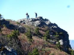
While not right on the Parkway,  a stop I recommend for everyone is Mount Mitchell State Park. Mount Mitchell’s dramatic summit is the highest point east of the Mississippi at 6,684 feet and was inspiration for one of the nation’s first state parks. From its easily accessible observation deck, the spruce-fir forest of Mount Mitchell State Park leads the eye to unmatched views. A museum explains the mountain’s cultural and natural history, and its trail network allows visitors to explore up close, offering short hikes near the summit and challenging treks leading to adjacent wilderness areas.
 We drove to the summit and took the short hike up to the observation deck. From here you have a 3600 view of the surrounding mountains –
  what a sight! Just below the summit is the grave of Reverend Elisha Mitchell, a professor at the University of North Carolina, who lost his life during scientific exploration of Mount Mitchell in 1857.
We hiked one of the nature trails from the summit to the parking lot. The vegetation in this ecosystem was quite different from what we have in Falls Lake.
 There are several waterfalls along the Parkway. We didn’t have the time to visit all of them and we chose to stop at Linville Falls. Linville Falls is probably the most photographed waterfall in North Carolina. It is said to be the most popular waterfall in the Blue Ridge Mountains because of its accessibility to the Blue Ridge Parkway. It is a spectacular three-tiered waterfall plunging into Linville Gorge, the “Grand Canyon of the Southern Appalachians.” It is a moderate 1.6 mile round trip hike, offering four overlooks of the falls, each revealing a different aspect of the falls. The Linville Falls start with a pair of waterfalls ending in a deep pool, but from there the pool empties into a corkscrew-like run to the bottom in the Linville Gorge. It is a fascinating geologic feature, and a unique experience.
 It was late in the day when we headed for our next stop, the Linn Cove Viaduct. The Linn Cove Viaduct hugs the face of Grandfather Mountain and is recognized internationally as an engineering marvel. This was the last section of the Parkway to be completed. The viaduct was needed because of the damage that a traditional cut-and-fill road would have caused to Grandfather Mountain. The viaduct is 1,243 feet long and consists of 153 segments weighing 50 tons each. The bridge’s segments were precast at an indoor facility at the south side of the parkway. After being transported to the bridge site, each section was lowered into place by a custom crane placed on either edge of the existing structure. The only work done at ground level was drilling for the seven footings which support the viaduct. There was no access road other than the Blue Ridge Parkway itself.
We arrived after the Visitor Center had closed and tried to find an observation deck that was 300+ feet down the trail, but we never did find it! However, we did get a great view of the Viaduct from the trail below.
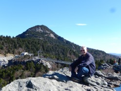
We spend the night in Blowing Rock, NC and got an early start the next morning to visit Grandfather Mountain. The weather was cool, but the skies were clear and the sun shining, promising that the day would only get better.  Grandfather Mountain is a non-profit attraction, and a North Carolina state park near Linville, North Carolina. At 5,946 feet, it is the highest peak on the eastern escarpment of the Blue Ridge Mountains, one of the major chains of the Appalachian Mountains.
Until 2008, Grandfather Mountain was privately owned and operated as a nature preserve and tourist attraction. It was and still is best known for its mile-high swinging bridge, the highest in America, built in 1952 by Hugh Morton. The bridge links two of the mountain’s rocky peaks, and is known as the “swinging” bridge due to its tendency to sway in high winds. Morton inherited the mountain from his grandfather and developed the tourist attractions.
On September 29, 2008, North Carolina Governor Mike Easley announced that the state had agreed to purchase 2,600 acres of the undeveloped portions of Grandfather Mountain from the Morton family for $12 million. The area has been added to the North Carolina State Park system, becoming the 34th North Carolina state park. Grandfather Mountain State Park was officially established in 2009.
 When we entered Grandfather Mountain we were given a CD that we could play as we drove through the park. It described the various features and scenes to watch for on the drive. Our first stop was the Nature Museum. What impressed me most was the display of minerals. I have never seen such a wide range of quartz in one place. Near the Museum is the Animal Habitats. Here you can see Bald and Golden Eagles, deer, bear, river otters and more in their natural habitat. All of the animals on display are animals that have been injured or in some way not able to live in the wild any more.
On our way to the top we stopped at the Black Rock parking area to check out the view. This part of the mountain is State-owned land and you could see the network of hiking trails that led through the backcountry. The view from here was just awesome. With the clear skies, you could see forever!
 We drove on to the top to walk across the Mile High Bridge. The bridge is 5,820 feet above sea level, hence the name, but the bridge is only 80 feet above the gorge below it. We climbed around on the rocky peak on the other side and enjoyed some absolutely marvelous views. We had lunch at a secluded picnic area that blocked the noise of the parking lot, yet had a nice view of the valley below.
 After lunch we headed back to Falls Lake, but we had one more stop to make. Just north of Greensboro is the site of the Battle of Guilford Courthouse. Guilford Courthouse was the turning point of the Revolutionary War in the South. The Americas under General Nathaniel Greene were too weak to defeat the British forces under General Charles Cornwallis. Greene had split his forces and engaged the British in a series of small actions, forcing Cornwallis to pursue him. Cornwallis destroyed most of his baggage wagons to speed up his pursuit. Greene chose to fight at Guilford Courthouse. Although he outnumbered the British, the Redcoats were better trained and disciplined fighters. Greene’s defense was in three successive lines, starting with colonial militia, and ending up with the veterans of the Continental Army.
  At the end of the battle, Greene, with light casualties, withdrew to an old camp fifteen miles away. Cornwallis occupied Guilford Courthouse and stayed in the area for a few days then, exhausted with heavy casualties, began a retreat toward Wilmington, NC. In the following months Greene regained control of South Carolina and Cornwallis retreated to Yorktown in Virginia where he surrendered on October 1781.
It was interesting to drive around the battlefield, much of it surrounded with private homes, watching people walk, bike and run on the road the National Park Service maintains to lead people through the battle. As a former infantryman I could visualize the British and American soldiers maneuvering through the woods and fields as I traced the battle. I’m always glad that sites like these have been preserved.
We returned to Falls Lake to resume our camp host duties.


Wow! That is quite the suspension footbridge, Bob! It’s been many years since Diana and I have been on the Blue Ridge Parkway. Thanks for the great photos…we will have to get back there soon.
Pingback: Raleigh, NC – October 2015 | Michigan Traveler